
Observation Spots
Formation
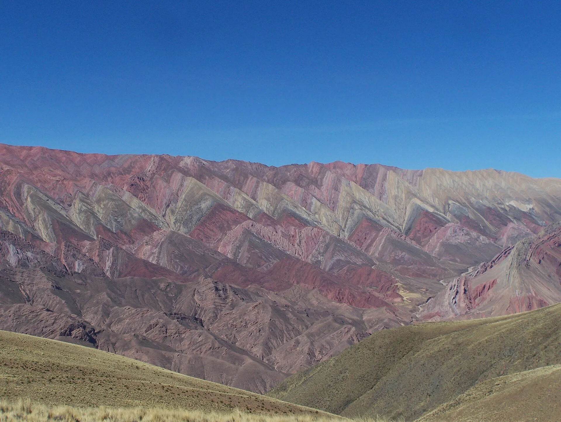
The gorge is a cross-section through deep time. Its walls expose marine and continental sediments laid down over hundreds of millions of years, from ancient shales near the base to far younger sandstones and gravels toward the rim, all lifted and tilted as the Andes buckled upward along the western edge of South America. What makes the rock read like a painting is mineral chemistry: iron oxides stain the beds red and purple, copper compounds tint others green, sulphur and clays add yellow and white, and manganese darkens the browns. Because the layers were folded to a steep angle before the Río Grande sliced down through them, whole sequences now stand almost on end, so a single hillside can show a dozen colours stacked side by side.
- Cerro de los Siete Colores at Purmamarca is the classic example — a compact hillside where seven mineral bands rise in a near-vertical sweep, best lit in early morning.
- The Serranía de Hornocal, about 25 km east of Humahuaca town at a viewpoint near 4,350 metres, folds its strata into a giant zigzag of pinks, teals, and creams that only catches fire in late-afternoon sun.
- La Paleta del Pintor (the Painter's Palette) rises directly behind the village of Maimará, its stripes so crisp they look freshly brushed.
The canyon's high-desert climate is part of the spectacle: at 2,000–3,000 metres the air is thin and bone-dry, almost all rain falls in a short summer wet season, and the near-permanent clear skies keep the colours sharp by day and the temperatures sharply cold after dark.
Trails
- Paseo de los Colorados, Purmamarca: an easy 3-kilometre dirt loop curling behind the Hill of Seven Colours, revealing red rock spires the roadside viewpoints never show — best walked in the first hour after sunrise.
- Pucará de Tilcara: a reconstructed pre-Inca fortress on a hilltop above the town, with panoramic canyon views, a cactus-studded approach, and a small archaeological museum of ceramics, tools, and burial finds.
- Adobe villages: Purmamarca, Maimará, Tilcara, Uquía, and Humahuaca keep their mud-brick architecture and unhurried pace. Uquía's 17th-century church is famous for its ángeles arcabuceros (angels carrying muskets), while Humahuaca's plaza stages a mechanical figure of San Francisco Solano that emerges to bless the town each midday.
- Serranía de Hornocal: the fourteen-colour ridge east of Humahuaca — a rough but drivable climb to a 4,350-metre balcony that is the single most dramatic viewpoint in the gorge.
- Salinas Grandes: a side trip west from Purmamarca over the Cuesta de Lipán, cresting above 4,000 metres before dropping to a blinding white salt flat on the Puna. Attempt it only with an acclimatised group and an experienced driver.
- Living Quechua culture: markets in Humahuaca and Tilcara sell dried llama meat, coca leaves, and hand-woven textiles, while August's Pachamama offerings and February's Carnaval keep pre-Columbian tradition alive.
Wildlife
The quebrada's arid landscape harbors a distinctive Andean ecosystem. Vicuñas — wild relatives of the llama with prized golden wool — graze on sparse vegetation at higher elevations, particularly visible on the approach to Salinas Grandes. Herds of domesticated llamas are a constant presence around the adobe villages. Overhead, Andean condors soar on thermals rising from the canyon walls, and smaller raptors like the aguilucho (variable hawk) hunt rodents in the scrubland. The endemic horned coot inhabits high-altitude lagoons near the Puna, and flocks of flamingos gather at salt lakes above 3,500 meters during the wet season. Hardy cardón cacti — some towering 10 meters tall and centuries old — dot the hillsides, providing nesting sites for parrots and woodpeckers. A naturalist guide transforms the drive into a rolling wildlife safari.
When to Visit
Canyon access: open year-round — the spine of the gorge is a public highway (Ruta Nacional 9) threading inhabited villages, so there is no gate and no closing time. Pucará de Tilcara: daily 9 AM – 6 PM.
Best season: April through November, the dry Andean winter, delivers deep-blue skies that make the rock colours pop and roads that stay open. May to September is the clearest and coldest — pack for near-freezing dawns. Avoid the December–March summer, when afternoon thunderstorms and occasional flash floods can close sections of RN9 and grey out the colours.
Timing within the day matters as much as the season. The eastern walls — including Purmamarca's Siete Colores — burn brightest before noon, while the Serranía de Hornocal only comes alive in late-afternoon light, so a well-planned circuit works north in the morning and saves Hornocal for the way back.
Duration: a full day as a round trip from Salta (290 km each way to Humahuaca town); two days with an overnight in Purmamarca or Tilcara is far more comfortable and lets you add Hornocal or Salinas Grandes.
Admission and Costs
Canyon access: free — RN9 is a public road, so the landscape itself costs nothing. Pucará de Tilcara entry: AR$5,000–10,000 ($5–10). Hornocal viewpoint: a small municipal fee of roughly AR$3,000–5,000 ($3–5) is collected on the access road. Guided day trip from Salta: AR$50,000–90,000 ($50–90) with transport and guide. Two-day tour with an overnight in Purmamarca: AR$120,000–200,000 ($120–200) per person. A local guide in Tilcara or Humahuaca runs AR$15,000–25,000 ($15–25) for a two-hour village-and-ruins walk. Prices shift constantly with Argentine inflation, so treat pesos as approximate and carry cash — card and ATM coverage in the canyon villages is thin.
The Case for a Guide
The quebrada rewards a good bilingual guide more than almost any drive in Argentina, because three separate stories — geological, archaeological, and living-cultural — are stacked in the same view, and none is legible on its own.
- Reading the rock: a guide explains why a hillside carries fourteen colours — which band is iron, which is copper, why the strata stand on end — turning a photo stop into geology you can follow.
- The pre-Inca and Inca layers: at the Pucará de Tilcara and along the old Qhapaq Ñan, a guide separates Omaguaca from Inca from colonial, so the ruins stop blurring together.
- Cultural respect: guides know when and how to photograph markets, Pachamama offerings, and Carnaval comparsas, and steer your money toward artisans rather than intermediaries.
- The hard logistics: timing the light for Hornocal, judging whether Salinas Grandes is safe on the day, and managing altitude are exactly the calls a local makes well.
- Context back in the city: pairing the drive with the Inca-mountain collections of the MAAM in Salta gives the whole itinerary a backbone.
Tips for Visitors
Start early from Salta. The drive is long — 290 km to Humahuaca town — and the northern light is best in the morning; a 7 AM departure puts you in Purmamarca by mid-morning with the Siete Colores still glowing.
Respect the altitude. Over the day you climb from Salta's 1,187 m through the gorge to Humahuaca's 2,939 m, and side trips go far higher — Salinas Grandes tops 4,000 m and the Hornocal balcony sits near 4,350 m. Drink mate de coca at the stops, hydrate, ascend gradually, and watch for headache or breathlessness.
Chase the right light. Save Hornocal for the afternoon and shoot the eastern walls in the morning — the good light on each is a couple of hours apart. The Siete Colores viewpoint in Purmamarca is best between 8 and 10 AM.
Photograph people only with permission, especially at markets and ceremonies, and buy textiles and coca directly from artisans rather than intermediary shops.
Fill the tank in Salta. Village pumps in the canyon exist but can run dry; carry cash, warm layers for the cold nights, and strong sun protection for the fierce high-altitude UV.
Frequently Asked Questions
When is Quebrada de Humahuaca open and which season is clearest?
Canyon access: Open year-round — it's a public road (Ruta Nacional 9) through inhabited villages. Pucará de Tilcara: Daily 9 AM - 6 PM. Best season: April through November (dry season) offers clear blue skies that make the rock colors pop.
How much does it cost to access Quebrada de Humahuaca?
Canyon access: Free — it's a public road through open landscape. Pucará de Tilcara entry: AR$5,000-10,000 ($5-10). Guided day trip from Salta: AR$50,000-90,000 ($50-90) with transport and guide.
What should visitors bring when visiting Quebrada de Humahuaca?
Drink coca tea at the stops and stay hydrated as the canyon rises to nearly 3,000m. Respect indigenous communities — ask permission before photographing people. Fill your tank in Salta as gas stations in the canyon can run dry.
Where are the most colourful mountains in Quebrada de Humahuaca?
Two stand out. The Cerro de los Siete Colores (Hill of Seven Colours) rises right behind Purmamarca and photographs best before 10 AM, when morning light hits its eastern face. The Serranía de Hornocal — the "Hill of Fourteen Colours" — is about 25 km east of Humahuaca town at a 4,350-metre viewpoint and only ignites in late-afternoon sun, so plan your route to reach each at the right time of day.
How many days do you need for Quebrada de Humahuaca?
One full day from Salta covers Purmamarca, Tilcara, and Humahuaca town, but it is a lot of driving — 290 km each way. Two days, with a night in Purmamarca or Tilcara, is far more relaxed and lets you add the Serranía de Hornocal viewpoint or the Salinas Grandes salt flats without rushing the light or the altitude.