Overview
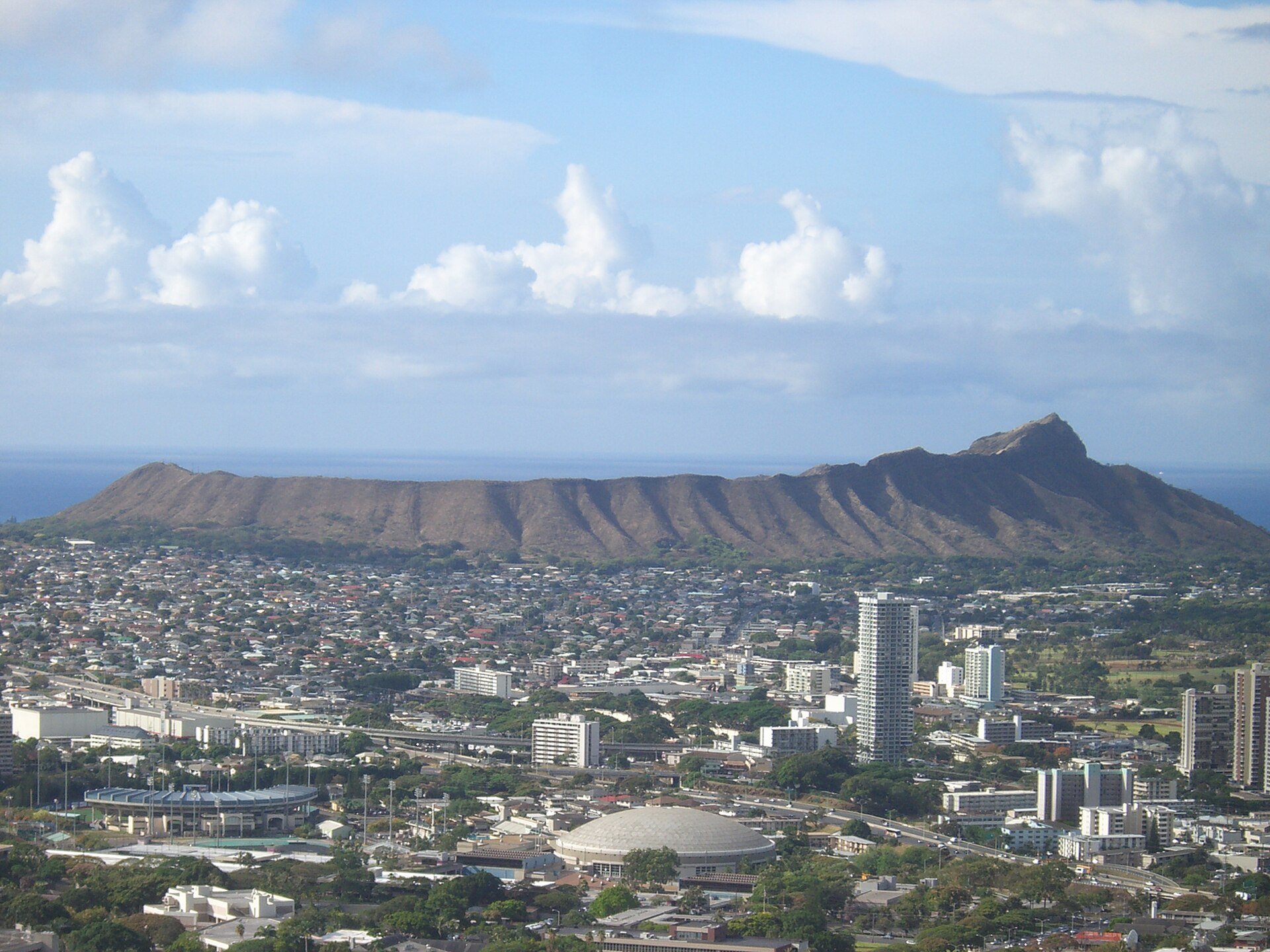
Diamond Head is the defining silhouette of Honolulu, a 760-foot volcanic tuff cone that rises from the southeastern edge of Waikiki Beach and has served as a navigational landmark for Polynesian voyagers, a military fortification for the U.S. Army, and the backdrop of virtually every photograph ever taken of Honolulu's coastline. Hawaiians called it Le'ahi, meaning "brow of the tuna," because the ridgeline resembled the dorsal fin of an ahi tuna when viewed from the sea. British sailors in the 19th century renamed it Diamond Head after mistaking calcite crystals glinting on its slopes for diamonds.
The crater formed roughly 300,000 years ago during a single explosive eruption that lasted only a few days, and it has been dormant ever since, its interior now a dry, scrubby basin crisscrossed by a hiking trail that leads to one of the most photographed viewpoints in the Pacific. The hike to the summit follows a 1.6-mile round-trip trail originally constructed by the U.S. Army in 1908 as part of Oahu's coastal defence system. Hikers pass through a tunnel bored into the crater wall and climb a 99-step staircase inside a former military observation post before emerging onto the summit platform. From the top, the view stretches from the high-rises of Waikiki and the turquoise arc of Hanauma Bay to the deep blue of the open Pacific and, on clear days, the outline of Molokai across the channel. A guide transforms this popular hike from a cardio workout into an education in volcanic geology, Hawaiian place-name traditions, and the military history embedded in the bunkers and observation posts along the trail.
Wildlife
The volcanic geology beneath your feet tells a 300,000-year story that most hikers never learn. Guides explain how a single explosive eruption lasting only days created this tuff cone, distinguish the light-coloured volcanic rock from the darker lava flows visible elsewhere on Oahu, and describe why Diamond Head is classified as extinct rather than merely dormant. They also share the Hawaiian name Le'ahi and the cultural significance the crater held for traditional navigators who used its distinctive profile to orient their voyages across the Pacific.
Military history pervades the trail in ways that go unnoticed without narration. The tunnel bored through the crater wall, the concrete bunkers positioned along the rim, and the observation posts commanding views in every direction were all constructed between 1908 and 1943 as part of Oahu's coastal defence network. Guides identify each structure, explain the strategic thinking behind their placement, and connect this hilltop to the broader story of Pacific military history that reached its dramatic climax at Pearl Harbor just a few miles to the west.
Even the sparse vegetation rewards informed observation. Naturalist guides identify kiawe trees, ilima plants bearing the official flower of Oahu, and pili grass that once thatched Hawaiian homes. Photography enthusiasts benefit from guides who have memorized exactly when morning light strikes the crater rim, the coastline, and the towers of Waikiki at their most photogenic angles, ensuring visitors capture images worth keeping rather than settling for midday glare.
Trails
Summit panorama: The 360-degree view from the concrete platform at the top encompasses Waikiki, Koko Head, the Waianae Range, and the Pacific Ocean stretching to the horizon. Military tunnel and stairs: The dark tunnel through the crater wall and the 99-step spiral staircase inside the observation post are the most dramatic moments of the hike.
Crater interior: Looking down into the dry, bowl-shaped interior from the rim trail reveals the full scale of the eruption that formed this landmark 300,000 years ago. Sunrise from the summit: Watch the sun rise over the Pacific while Waikiki's towers catch the first golden light below you. Lighthouse viewpoint: About halfway up, a side lookout offers a clear view of the Diamond Head Lighthouse and the surfers riding the reef break below the cliffs. Koko Head in the distance: From the summit, look southeast to see the jagged profile of Koko Head crater and the deep blue cove of Hanauma Bay beyond. Fire control station: The flat-roofed concrete bunker at the very top was built in 1911 to coordinate artillery fire across Oahu's south shore and now serves as the primary viewing platform.
When to Visit
Park hours: Open daily from 6 AM to 6 PM; last entry at 4 PM to ensure hikers can descend before closing. Sunrise hikes: Arriving at the gate by 6 AM allows you to reach the summit for early morning light, when the air is coolest and the view is sharpest. Advance reservations required: Since 2022, all visitors must book a timed entry reservation online; walk-ups are not guaranteed.
Best conditions: Early morning before 8 AM or late afternoon after 3 PM; midday sun on the exposed trail makes the climb significantly harder. Avoid: Weekend mid-mornings from 9 AM to noon, when the trail becomes congested and the summit platform is standing-room only.
Admission and Costs
Entry fee: $5 per person for non-residents; free for Hawaii residents with valid ID. Parking: $10 per vehicle inside the crater; limited to about 150 spaces that fill early. Guided sunrise hike: $30-50 per person including transportation from Waikiki and naturalist narration.
Private geology and history tour: $150-250 for a 3-hour guided hike for up to 4 people with in-depth geological and military history commentary. TheBus route 23: $3 each way from Waikiki to the Diamond Head trailhead, the most affordable option if the parking lot is full.
Tips for Visitors
Reserve in advance: Timed entry reservations are mandatory and often book up days ahead for morning slots; plan early, especially for sunrise. Bring plenty of water: The trail is fully exposed with no shade or water stations; a litre per person is the minimum on hot days. Wear proper footwear: The trail is paved but steep and uneven in places, with the staircase and tunnel requiring sure footing; sandals and flip-flops are a bad idea.
Budget 1-2 hours: The hike is 1.6 miles round trip and takes most people 90 minutes to 2 hours including time at the summit. Combine with Waikiki Beach: The trailhead is a short drive or bus ride from Waikiki, making a sunrise hike followed by a beach morning a perfect half-day plan. Flashlight for the tunnel: The tunnel through the crater wall is dark and about 225 feet long; a phone flashlight works but a small headlamp is better. Hat and sunscreen essential: There is zero shade on the upper trail and summit; the tropical sun at this latitude burns fast, even on overcast mornings.