_and_Belfry_of_Bruges,_Bruges,_Belgium_(Ank_Kumar,_Infosys_Limited)_05.jpg)
Overview
The canals threading through Bruges weren't scenic afterthoughts but the hydraulic infrastructure that made the city wealthy. From the 12th through 15th centuries, these waterways connected inland Bruges to the North Sea port of Damme, allowing wool from English sheep to arrive by ship and depart as Flemish cloth valued across Europe. Merchants built their warehouses with water gates opening directly onto the canals — boats loaded with Spanish wine, Baltic timber, and Italian silk could unload straight into storage cellars that still exist beneath gabled houses. The Reie river winds through the historic center in concentric loops, augmented by engineered channels that controlled flooding while maximizing commercial frontage. Walking Bruges gives you Gothic architecture and cobblestones; experiencing it from the water reveals why the city exists where it does and how medieval logistics actually functioned. Five boat companies operate from different landing stages scattered around the center — near the Vismarkt fish market, behind the Church of Our Lady, along Dijver near the museums, at Huidenvettersplein (Tanners' Square), and by the Rozenhoedkaai (the most photographed view in Bruges). Each company runs 30-minute loops through slightly different routes, but all navigate the same basic circuit: east toward the Beguinage convent with its white-gabled houses, south past the Bonifacius Bridge and medieval hospital, west under the Meebrug where willow branches drag through the water, north past warehouse conversions now housing museums and luxury apartments. The boats themselves are flat-bottomed fiberglass vessels seating 30-40 passengers, deliberately designed low-profile to clear the stone bridges by sometimes terrifyingly narrow margins. During spring high water, boats occasionally can't pass under certain bridges, forcing route modifications that local guides announce with grumbling about modern drainage systems. The canal perspective transforms familiar landmarks into architectural compositions impossible to appreciate from street level. The Church of Our Lady tower (122 meters) rises behind a foreground of stepped gables reflected in still water — the boatman cuts the engine at this spot, letting the boat drift silently while passengers photograph what looks like a Renaissance painting come to life. Passing under the Bonifacius Bridge, you see the medieval brickwork up close: weathered red clay sourced from Flemish river deposits, laid without mortar in patterns that allowed flexibility as foundations settled. Private gardens invisible from streets reveal themselves from the water — roses climbing limestone walls, swans nesting in reed beds, terraces where residents drink coffee watched by tourists floating past like voyeurs. The canals also expose Bruges' modern interventions: steel reinforcement bars added to crumbling quays, contemporary apartments designed to mimic medieval proportions, underwater lights installed for evening boat tours that illuminate the water in cinematic blues. The boat guides provide commentary in three or four languages — Flemish Dutch, French, English, and sometimes Spanish or German depending on passenger composition. Quality varies wildly by individual guide and company. The best narrators contextualize what you're seeing: explaining how the Tanners' Guild located specifically along this stretch because their malodorous tanning vats needed canal water for waste disposal, pointing out the narrow slits in warehouse walls where chains and pulleys hoisted cargo, identifying which gables date genuinely to the 15th century versus which are 19th-century restorations rebuilt after French Revolutionary vandalism. Mediocre guides recite the same "Venice of the North" clichés and mispronounce historical names. If you're serious about understanding Bruges' hydraulic history, hiring a private guide for a walking tour that includes canal perspectives provides more depth than the boat commentary alone, though nothing replaces the sensory experience of gliding beneath bridges and willow curtains at water level. The canals attract wildlife that thrives alongside tourist traffic. Swans — Bruges' municipal symbol since the 1488 execution of Pieter Lanchals (whose name translates to "long neck") supposedly cursed the city to maintain swans forever — glide between boats with aristocratic indifference. Coots build nests in canal-side vegetation, their chicks riding on parents' backs during April-May breeding season. Mallards paddle in formation, sometimes following boats for thrown bread despite city regulations prohibiting feeding (guides wearily remind tourists every few minutes). Herons stalk the shallow sections near the Beguinage, stabbing at fish with pterodactyl precision. The canal ecosystem demonstrates how medieval cities functioned as productive landscapes, not sterile monuments — water that moved goods also supported fisheries, waterfowl hunting, and flax retting for linen production. Modern Belgian ecology protects these same waterways through strict water quality standards, though the swans remain aggressive and entitled regardless of century. Seasonal variations dramatically alter the canal experience. Spring brings the famous overhanging willows into full leaf, their branches creating green tunnels that boats glide through while passengers duck to avoid nature's face-slapping. Summer sun dapples through foliage, but also brings maximum crowds — expect queues at popular landing stages during July-August afternoons. Autumn transforms the gables into rust and ochre reflections, the water darkening as daylight shortens, frost occasionally edging the banks by November. Winter sees reduced schedules (some companies close December-February), but when boats run, the empty canals and bare branches reveal architectural details obscured by leaves. The canals freeze perhaps once every five years during exceptional cold — locals ice skate the circuits when conditions permit, reliving paintings by Bruegel that depicted the same waterways frozen solid 450 years earlier. The most photographed spot in Bruges frames the Belfry rising behind gabled houses reflected in the Rozenhoedkaai canal junction. Every tourist with a camera crouches at this corner, recreating an image that appears on a million Instagram feeds and postcard racks. The boat tour passes this exact spot from water level, providing the alternative view — looking up at the throngs of photographers shooting down at you, realizing you've become part of someone else's picturesque Bruges composition. This reversal captures something essential about the canal experience: it defamiliarizes the city, making you see familiar tourist images from unexpected angles. The canals aren't just pretty; they're epistemological tools for understanding medieval urbanism from the inside out, revealing infrastructure that street-level tourism usually obscures behind aestheticized façades.
Engineering Facts
The Reie river system that feeds Bruges' canals was extensively engineered during the 12th-13th centuries to serve both commercial and defensive functions. Medieval hydraulic engineers diverted natural watercourses into concentric loops around the city center, creating navigable channels wide enough for flat-bottomed cargo barges while simultaneously forming a defensive moat system. The stone bridges — including the Bonifacius Bridge, Meebrug, and Augustijnenbrug — were built with precisely calculated arch clearances that allowed loaded barges to pass while keeping the bridges low enough for horse-drawn cart traffic above. The canal walls use Flemish brick bonding techniques, with foundations driven into clay subsoil on wooden piles that remain sound after 700+ years due to constant water saturation preventing rot. Water level management relied on a system of sluizen (sluice gates) at the city perimeter, controlling flow from the Reie and preventing both flooding during spring rains and stagnation during summer droughts. The canal system's gradual silting after the 15th century — as the Zwin inlet connecting Bruges to the sea filled with sediment — directly caused the city's economic decline, preserving its medieval character by removing the commercial incentive to modernize.
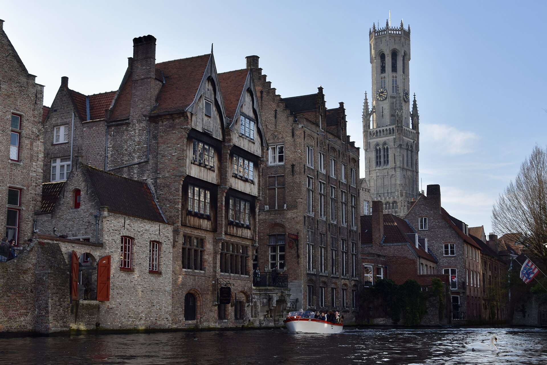
Observation Points
Rozenhoedkaai: The most photographed spot in Bruges, where the canal junction frames the 83-meter Belfry rising behind stepped gables — seen from boat level, the perspective reverses the classic postcard view. Bonifacius Bridge: The stone footbridge creates a perfect arch framing medieval gables beyond — boats pause here for photographs. Church of Our Lady view: The 122-meter tower rises behind stepped gables reflected in water — the composition that defines Bruges' silhouette. Willow tunnels: Along the Dijver and near the Begijnhof, overhanging willows create green curtains boats glide through in spring and summer. Swan encounters: Bruges maintains a population of mute swans on the canals — municipal symbols since 1488, often aggressive, and completely fearless around boats. Water gates: Medieval warehouses built with canal-level loading doors are still visible along the Dijver — guides point out original cranes and pulley mechanisms. Begijnhof approach: The convent's white-gabled houses and garden walls seen from water form a cluster separate from the city center, revealing its original function as enclosed religious community.
When to Visit
Operating season: Daily March through November 10:00 AM - 6:00 PM (extended to 8:00 PM June-August). Winter schedule: December-February hours reduced; some companies close entirely — check individual operators. Best: Early morning (10:00-11:00 AM) or late afternoon (5:00-6:00 PM) for softer light and smaller crowds. Avoid: Midday (12:00-3:00 PM) in July-August when cruise passengers create 30-45 minute waits. Spring bonus: Late March through April — willows leaf out, birds nest, water reflects perfect mirror images before summer haze arrives. Evening tours: July-August only, some companies offer evening departures with underwater lighting — romantic but you miss architectural details in darkness
Admission and Costs
Standard tour: €10-14 per adult depending on company and season — all tours are approximately 30 minutes. Children: €6-8 (ages 4-11), free under 4 if sitting on laps. Group discounts: €9-12 per person for groups of 20+ booking in advance. Private boat charter: €150-200 for entire boat (capacity 30-40) — useful for groups wanting customized commentary. Combo tickets: Some companies offer packages with museum admission (€25-30) — check if museums included are ones you planned to visit anyway
Tips for Visitors
Skip the queue: Rozenhoedkaai and Vismarkt landings get longest waits. Walk to Huidenvettersplein or the landing near the Beguinage for shorter lines. All companies cover similar routes: Don't agonize over which boat company to choose. Guide quality varies by individual, not company — you're taking a chance either way. Sit at the back: Rear seats get better views passing under bridges and looking back at what you've just cleared. Front seats duck lowest to avoid hitting arches. Bring a waterproof bag: Spring and autumn bring rain; even without rain, passing under some bridges drips moss and condensation onto passengers. Photography strategy: Shoot continuously as you pass under bridges — the framed views last only seconds. Forget about perfect composition; quantity over quality captures the best moments. Combine with walking: Take a boat tour first to get oriented, then walk the canal banks on foot to appreciate details the guide pointed out. The Groeninge Museum sits right on the Dijver canal. Language check: Guides announce commentary languages before departure. If you need English and the guide is doing Flemish/French only, wait for the next boat. Winter closure: Many companies shut down December-February. If visiting off-season, check websites before planning your itinerary around a canal tour that might not be running.